The path of the sol 1592 drive is a yellow line.
Screen capture from the official map (with annotated sol numbers on the waypoints.
View the entire traverse (since landing) on the official JPL mission map using this link

The path of the sol 1592 drive is a yellow line.
Screen capture from the official map (with annotated sol numbers on the waypoints.
View the entire traverse (since landing) on the official JPL mission map using this link
Perseverance appears to have abandoned trying to climb higher uphill (after several unsuccessful attempts were foiled by loose terrain)
Instead it drove down-slope towards the southwest and close to the notional path that could take it to the south, and a number of predefined science waypoints.
The image is a post-drive tiled-NavCam.
Credits: NASA/JPL-Caltech

This image was taken by Chemistry & Camera (ChemCam) onboard NASA's Mars rover Curiosity on Sol 4626 (2025-08-11 07:08:31 UTC).
ChemCam is a suite of remote sensing instruments on Mars for the Curiosity rover. As the name implies, ChemCam is actually two different instruments combined as one: a laser-induced breakdown spectroscopy (LIBS) and a Remote Micro Imager (RMI) telescope.
The purpose of the LIBS instrument is to provide elemental compositions of rock and soil, while the RMI will give ChemCam scientists high-resolution images of the sampling areas of the rocks and soil that LIBS targets.
The LIBS instrument can target a rock or soil sample from up to 7 m (23 ft) away, vaporizing a small amount of it with about 30 5-nanosecond pulses from a 1067 nm infrared laser and then observing the spectrum of the light emitted by the vaporized rock.
Credits: NASA/JPL-Caltech/LANL

EDIT - Added the 5 missing images

Just a quick screen grab from the official on-line map, the scale is shown in the lower left corner of the map.

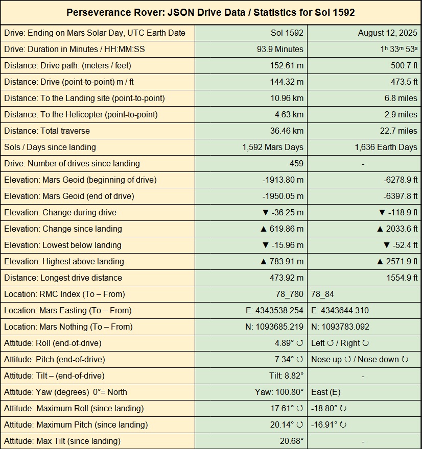
The table is extracted from drive data published by JPL, they update the data shortly after each drive. It's is provided by JPL in JSON format. If anyone wants the JSON URL's to review the traverse data I can post them here, let me know!

Data released by NASA/JPL shortly after each drive

Having another go at climbing higher up the steep slopes of the outer rim wall of Jezero crater. This drive took the rover ESE, and it finished the drive with its nose raised by a little over 20 degrees. It can safely climb much steeper slopes, but not slopes that have an abundance of loose material like the rover has encountered on this slope.
The image is a processed post-drive rear facing HazCam looking down slope. Look closely and you can see that the wheels (especially the one on the left side of the image) appears to have been slipping and bunching up rubble down slope. I'm assuming that the drive was likely halted by a lack of forward progress.
image credits: NASA/JPL-Caltech

Roughly assembled from 8 overlapping mast camera images, this workspace mosaic shows part of the terrain in reach of the rover's robotic arm. The tiny target from my last post is circled on the mosaic.
Credits: NASA/JPL-Caltech/MSSS

NASA's Mars rover Curiosity acquired this image using its Mars Hand Lens Imager (MAHLI camera), located on the turret at the end of the rover's robotic arm, on August 9, 2025, Sol 4624 of the Mars Science Laboratory Mission, at 08:25:03 UTC.
The camera focus motor count (returned with this image) can sometimes be used to calculate the camera standoff distance (camera lens to the target).
In this case the focus count indicates a standoff distance of ~5 cm (2 inches). That standoff equates to an image scale of ~25 micrometers per pixel, or a scene width of ~4 cm (1.57")
There's a lot of dust obscuring the surface of the rock, let's see if the team command the DRT to attempt to clear some of that dust so we can get a closer look at this interesting target
Credits: NASA/JPL-Caltech/MSSS


Here's a processed tiled mosaic by Simeon Schmauß
Perseverance rover captured this afternoon view of clouds above the Nili Planum region on Sol 1584.
The raw images from the left and right Navigation camera were undistorted, leveled and stacked to reduce noise. The resulting image was then color calibrated and white balanced to approximate what the human eye would see on Mars.
Additional processing was applied to reduce some glare that stems from dust on the camera lens and the sky was enhanced slightly to bring out the detail of the clouds.
Credit: NASA/JPL-Caltech/Simeon Schmauß (licensed as CC BY 4.0) Link to source
Didn’t they have a plan to shred a piece of the tire off?
Here's the JPL report that describes the process of shedding a wheel: https://jumpshare.com/s/jNrW1MDWWCi1m8o7oDGS
The link will expire in 24 hours (free service), if anyone wants it after that, I can re-upload


Here is the 'After' image (post LIBS)
Credits: NASA/JPL-Caltech/LANL