June 20, 2025 - Sol 4577

that’s cool! I guessed either for camera scale purposes or luck and got pretty close!
You were spot on.
For those that don't want to follow the link....
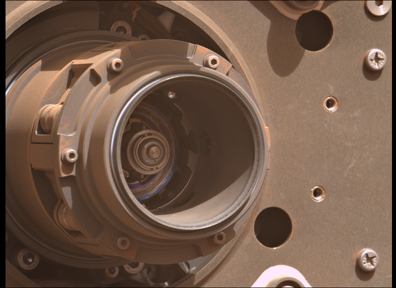
The Lincoln penny in this photograph is part of a camera calibration target
The calibration target for the Mars Hand Lens Imager (MAHLI) instrument also includes color references, a metric bar graphic, and a stair-step pattern for depth calibration. The MAHLI adjustable-focus, color camera at the end of Curiosity's robotic arm can be used for taking extreme close-ups of rocks and soil on Mars, rover selfies, as well as images from greater distances.
The penny is also a nod to geologists' tradition of placing a coin or other object of known scale as a size reference in close-up photographs of rocks, and it gives the public a familiar object for perceiving size easily when it will be viewed by MAHLI on Mars.
The specific coin, provided by MAHLI's principal investigator, Ken Edgett, is a 1909 "VDB" penny. That was the first year Lincoln pennies were minted and the centennial of Abraham Lincoln's birth.
Why a 1909 penny? Curiosity was going to launch in 2009, the centennial of the Lincoln Cent and bicentennial of Lincoln’s birth. When the launch was delayed, Ken made the decision to stick with the historic 1909 cent rather than try to find a 1911 cent as the coin was bonded into the calibration target and had already been delivered to NASA.
And it was lucky, despite many issues along the way, Curiosity has been exploring Gale crater since August 2012. In that time it's amassed enough science data to keep scientists busy for years.
June 20, 2025 - Sol 4577

Huge difference. It's a pity we have to suffer the current limits for data transfer between Earth and Mars. Some of the orbiting assets are aging rapidly, so data limits are not going to improve any time soon, else we could hope for many more images at different times of the day.
Credits: NASA/JPL-Caltech/MSSS/UofA

The drive distance may be amended later as there are 2 official data sources, and the one I don't usually use indicates the distance was a little longer at 405.49 m. I've decided to report on the shorter one for the time being

end-of-drive upper tier NavCam looking south after the second longest daily drive since landing. Credits: NASA/JPL-Caltech.

Bring twice as much water as you think you’re gonna need.
And an extra jacket, as it get a bit nippy after sunset ;)
A pair of end-of-drive NavCams show us the new workspace after a drive on sol 4575 (June 20, 2025)

Back in the day, someone used to do something like that with MSL images, but not seen any in ages, maybe someone here can take up the challenge :)
Assembled from 15 overlapping L-MastCam sub-frame Bayer reconstructed images from sol 4573. It's the rover's current workspace. Not sure how long they will stay here, but the journey to the next major science waypoint (Boxworks) to the south will continue soon.

Good map, I like the sol numbers!
Mine are simple screenshots from the official traverse map with annotated sol numbers (when I have time)
If you want to see the most detailed MSL traverse maps follow Jan Vacek (JV Honza) on Mastodon, or just follow this link for his most recent recent post.
Perseverance rover acquired this image of the coring bit located in the Carousel using its SHERLOC WATSON camera, located on the turret at the end of the rover's robotic arm. The image has been rotated to correct the orientation of the carousel.
This image was acquired on June 18, 2025 (Sol 1538) at the local mean solar time of 15:21:21.
Image Credit: NASA/JPL-Caltech

Perseverance rover acquired this image using its onboard Sample Caching System Camera (CacheCam), located inside the rover underbelly. It looks down into the top of a sample tube to take close-up pictures of the sampled material and the tube as it's prepared for sealing and storage.
The tube can be reused for further coring attempts
This image was acquired on June 18, 2025 (Sol 1538) at the local mean solar time of 14:28:07.
Image Credit: NASA/JPL-Caltech

Perseverance rover acquired this image using its Left Mastcam-Z camera at full zoom. Mastcam-Z is a pair of cameras located high on the rover's mast. No obvious damage is seen and they managed to remove the coring bit that was being used when the coring operation shattered the bedrock.
This image was acquired on June 18, 2025 (Sol 1538) at the local mean solar time of 15:08:18.
Image Credit: NASA/JPL-Caltech/ASU
I'm assuming the delay is due to engineering checks on the drill and it's electrical circuits. One of those broken plates appears to have been wedged between between a drill support, and the coring bit. If it was wedged tightly, the sudden additional load on the drill motor may have tripped the rotation of the drill, or if it tripped because the sensors in the robotic arm detected the movement that we can see in the image set.
Whatever it was, I'm assuming that they will need to check out the hardware and electric systems. JPL can communicate in direct mode to the rover rather than through the orbiters for engineering activities. We we would normally be able to see that direct communication on the DSN, but each time I have checked it today there has been zero communications activity from any of the mission missions. that's either a fault or it's another cutback.
DSN: https://eyes.nasa.gov/apps/dsn-now/dsn.html
BTW I'll volunteer to go and check out those fractured rocks. I just need a ride ;)
you can’t break bedrock!
Unless you phase through the bedrock ;)
Smells like rotten Eggs. You can lick the rock, but blow all the dust off first, as that contains lots of Perchlorate, enough to make it a bad day
Great comparison using the before and after shots. Fully agreed regarding the diverse mineralogy found in this mission. When I first saw these close-ups of the rock fractured by the drill, I thought maybe we were seeing thick mineral fill fractures, we've seen thin fracture fills on this mission, but if these are very large veins, that would be a first for Jezero (AFAIK). Whatever they are I agree that this stuff needs the 'full treatment' with all available instruments :)
Apologies not required :)
Looking at the current stats for this post, someone has made 24 cents :)