OpenStreetMap + App = OsmAnd!

306 readers
2 users here now

OsmAnd is a great open source Maps mobile app that uses OpenStreetMap!

founded 5 years ago
MODERATORS
1


Hello everyone!

After getting advice from my previous post in here (https://programming.dev/post/32038961) I've managed to build a super simple web app which converts google maps links to osmand.net links. As can be seen from the page if you visit it, to have it open those links in your mobile application automatically there are a few simple steps you need to go through to allow OsmAnd to open those links by default. It's a one time setup though.

I made it work both on desktop and mobile (it can be installed as a PWA - "Add to home screen").

Something that is quite important to me: it has some screen reader support for visually impaired people. Not being visually impaired myself, I can't know if its actually useful or if the tools I used to test the screen reader support are actually what the blind community use day-to-day. As such, I would really appreciate any feedback regarding (not only) the accessibility for visually impaired people.

Furthermore, please just let me know your thoughts in general and test the crap out of it. Im no web developer so if you find any security holes do let me know, even though its such a simple app that there shouldnt be much.

Also, general feedback is always appreciated!

Link to page: gmaps2osm.de

Link to github: https://github.com/promitheas17j/gmaps2osm

2


Hello guys, I'm relatively new to OSM but have found it quite useful and feature-rich since I made the switch to a degoogled phone OS. I now have a question about generating OSM compatible links much like google maps has where I can send a friend a sharable link and when they click it it automatically opens their app (or browser if the app cant be found) to the OSM map with the location under a pin so that they can do whatever with it (most usefully is to "Navigate" to it and get directions)

I'm so new to it though that I don't even know if the concept of a "link" which opens the map exists in the context of OSM. If it does though, I would love to know where I can read up on these links' formats so that I can see how I might generate them from lat+long coords through software.

Many thanks in advance!

Edit: In OsmAnd when I want to share a location, I can select Share then Copy. That will put some text along with a link of the following format in my clipboard:

https://osmand.net/map?pin=35.96296%2C-5.50856#10/35.96296/-5.50856

I get the parts up until the #10. What does the #10 mean and why do the coordinates appear 2 times in the link, once before #10 an once after?

3
4
5


This command transfers the favourites from OSMand to the PC:

$ adb pull storage/sdcard0/Android/data/net.osmand.plus/files/favourites.gpx

That much works as far as making a backup copy. But then I wanted to expand descriptions so that e.g. restaurants would have a detailed description of the food. The favourites.gpx file has MSDOS carriage returns, so I piped it through dos2unix and edited in emacs. Then I ran the file through unix2dos before pushing it back to the device while OSMand was not running:

$ adb push favourites.gpx storage/sdcard0/Android/data/net.osmand.plus/files/

Most of my edits were to simply add a descrption with the <desc> tag. Some of my changes involved color modifications to the icons by simply changing the hex inside the tags like this:

<wpt …
    <extensions>
      <osmand:color>#10c0f0</osmand:color>
    </extensions>
  </wpt>

None of my description changes had any affect. OSMand remembered the previous favourites. This means there is an update anomaly in the design of OSMand because there are multiple copies of the same data running around. Strangely, some of my color changes took effect and some did not. The inconsistency is disturbing.

Apart from altering favourites.gpx, there is a dodgy import feature. If I re-import a favourites.gpx file after updating it, would OSMand be smart enough to apply the changes without creating duplicate favourites? If so, what is used as the primary key? The coordinates?

Anyway, it’s dodgy as hell. I started to go through the import process. Tapped the “+” icon. It asked: “Complete action using: Aria2App or Documents”? Aria2App is some broken shit that I installed, so i chose “documents”. Then it gives a choice of these directories: Recent, Images, Videos, Audio, Downloads”. That’s it. None of this makes sense. This limited selection of file locations are not places where I would put a GPX file.

Theoretically, the GPX file could be staged in Videos just to do this import, but I struggle to trust it.

(edit) I think the primary key is the name of the favourite. In one case I altered the name of the waypoint and I ended up with two favourites for the same location. Apparently when the name of an updated favourite does not change, OSMand just tosses out the updated record and keeps the old. I also noticed that when using the app to create a new favourite with the same name as another, the app appends “(1)” forcefully.

6


I’m messing around with settings to make OsmAnd maps look similar to Google/Apple maps in terms of detail and colour scheme.

Any recommendations on how to achieve that?

Closest I got was a Microsoft Maps overlay style, but it’s somewhat blurry on iPhone.

7


I have noticed that OSMAnd has all kinds of icons and symbols to represent different attributes of objects. For example, if the Sport tag is equal to a certain value, it might have a certain icon, and if it's a different value, it might have a different icon.

I want to update some of these icons to better represent the things that are written in the OSM Wiki.

I'm not an app developer so I'm not sure exactly how to contribute but I'm guessing that if it's just checking icons and stuff like that I should be able to contribute myself.

I tried looking over the repository and I couldn't really figure out where to start from so if anyone here can just point me in the right direction I will go over and start reading the code but currently I'm not sure where to start from and I would appreciate it if anyone can point me to a specific file or section that I should look at.

8


Osmand doesn't appear to be able to locate street addresses. Like if I input something like "123 4th Street" all it can do is offer some cross streets, which may be miles away from my intended location.

Is there a way to augment it's data so street addresses work? Maybe there's a service I can add?

Similarly, it doesn't know the names of many businesses.

9


Qn^

How to disable minor roads while zooming out?

10


OSMand used to only crash 1 or 2 times per trip. It was usable enough. Now recently something changed with my config somehow and it shows extreme detail no matter how zoomed out I am. Every tiny street is being rendered. This is killing the app. It crashes so chronically it’s unusable.

Anyone know how to control this?

In “configure map” I have disabled everything except cycling routes. The “details” shows 0/9, which apparently only configures objects, not street details.

(edit) I think the “map magnifier” might be the issue. It was at 25% (the lowest), which I would intuitively think means less road detail. But it’s apparently counter-intuitive. I chose 100% and I seem to get less map detail -- which is what I need because the more detail, the more crashes. So I might have solved this.. need to experiment.

11
2
submitted 8 months ago* (last edited 8 months ago) by [email protected] to c/[email protected]


Is it possible? (waze has mp3 files available) - https://github.com/pipeeeeees/waze-voicepack-links

[EDIT] osmand path is : /storage/emulated/0/Android/data/net.osmand.plus/files/voice/en

Going to try replacing some of those files, as long as purpose matches. I'll update this thread.

12


I'm using a pixel 6 with gapheneos currently. I'm looking for a phone that is fast enough to use osmand without the 5 second lag when it has to render all details. Any advice?

13
3
Creating (adding) POIs (programming.dev)
submitted 10 months ago* (last edited 10 months ago) by [email protected] to c/[email protected]


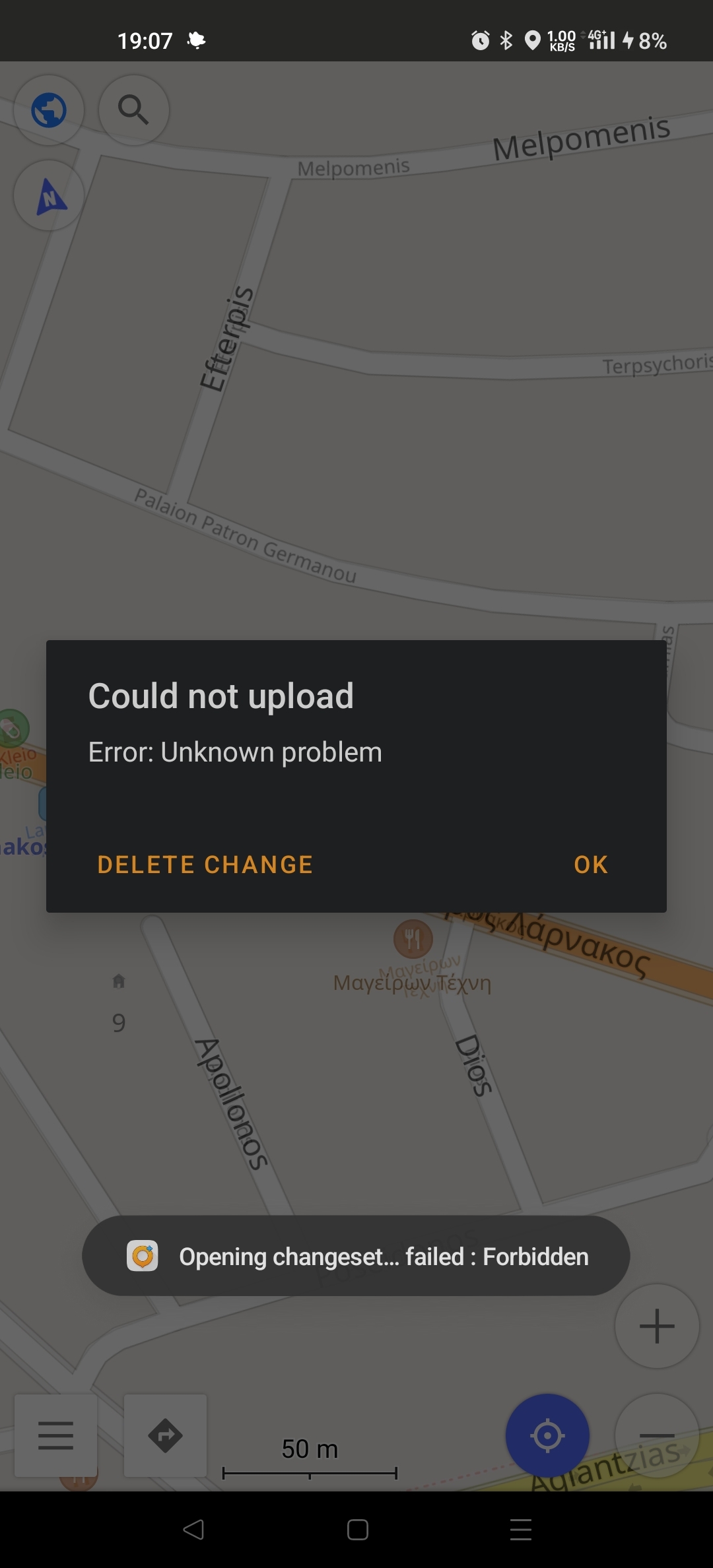
I would like to contribute to the maps for my area by creating and uploading various POIs as I come across them in my daily use. To get familiar with the system I decided to add a known to me florist. I found the exact location using google maps, opened it in OsmAnd+, and went through the process to add all its details (address, phone, website, type, etc). However when I decide to upload it, signing in with username and password, I get the error in the image attached. Anyone know what the problem is and how I can solve it?

Edit: App Info OsmAnd+ 4.6.12, Released: 2024-01-16

14


Street Complete is quite dysfunctional for me. I just get a beige background with icons (+) (-) (ø) ≡. Long tapping gives:

  • create new note
  • create new track recording
  • open location in another app

There is no way to specify a location to edit. If I go online and turn on GPS, the screen fills with questions to answer but still no map.

How do I get a map?

How do I specify a location to go to?

15


Whoever designed the OSM db either never uses ATM machines or they have never experienced anything like the ATM disaster in Netherlands. The OSM db has most ATM brands incorrect for Netherlands and seriously needs more fields so travelers can actually find a functioning ATM.

brands are mostly incorrect

Pick any Dutch city. Search » Categories » custom search » Finance » ATM. The brands are mostly misinfo. These ATM brands do not exist anywhere in Netherlands:

  • Rabobank
  • ABN AMRO
  • Ing
  • SNS

All those banks removed all their ATM machines and joined a monopolistic consortium called “Geldmaat”. There is generally an ATM at those locations but it’s always a Geldmaat ATM. So a simple find and replace is needed on all the Dutch maps.

For indoor ATMs, the brand is often incorrectly named after the shop it’s in. That’s useful for finding it but still missing important info: the actual ATM brand. ATM brand is very important because different ATM brands give differing degrees of shitty treatment. If brand X refuses your card, all instances of that ATM brand will likely refuse your card. So the “brand” field should always reflect the ATM operator. Having a separate shop name field would be useful for locating the machine.

missing key attributes

Travelers should not have to spend hours running from one ATM to another until they find one that works. There are lots of basic variables that need to be accounted for in the db:

  • (real or fixed point) ATM fee
  • (enum set) currencies other than local (a rare but very useful option is to e.g. pull out GBP or USD in the eurozone)
  • (enum set) card networks supported (visa, amex, discover, maestro, etc)
  • (enum set) UI languages supported
  • (integer) transaction limit for domestic cards
  • (integer) transaction limit for foreign cards
  • (integer set) denominations in the machine (Netherlands quietly removed all banknotes >€50 from all ATMs IIUC)
  • (boolean) whether customers can control the denominations
  • (boolean) indoor/outdoor (if the txn limit field is empty, indoor machines often have higher limits)
    • (string) hours of operation (if indoor)
    • (string) name of shop the ATM is inside (if indoor)
  • (enum) whether a balance check is supported: [no | only some cards | any card]; this feature is non-existent in Belgium but common in Netherlands. Note that some ATMs only give balance on their own cards.
    • (enum) whether the balance is on screen or printed to the receipt, or both
  • (boolean) insertion style -- whether the card is sucked into the machine (this is very important because if the card is sucked in by a motor there is a real risk that the machine keeps the card [yes, that’s deliberate]). Motorised insertion is more reliable but carries the risk of confiscation. Manual insertion can be fussy and take many tries to get it to read the card but you never have to worry about confiscation.
  • (boolean) dynamic currency conversion (DCC)
  • (boolean) whether there is an earphone port for blind people (not sure if that’s always there)
16


Hey, like many people, the search feature sucks for me. Is there an easy and reliable way to share a POI (restaurant, store, whatever) from google maps over to OSMand?

17
18


I just added the Strava heatmap as a layer in one of my maps and this is very cool. Definitely better than in the actual app.

What are some other cool online maps you've integrated into osmand?