Weather and Meteorology

179 readers
9 users here now

Hope to expand on this later. A community for discussing the weather (very UK), amateur meteorology, and moaning it's too hot/cold/wet/dry/mild.

founded 2 years ago
MODERATORS
1


Storm Éowyn has been named by the Met Office and will bring severe gales to parts of the United Kingdom on Friday.

The Met Office has issued yellow warnings for wind on Friday and Saturday.

Gusts of up to 90mph (145km/h) - or possibly even more - could bring localised damage, power cuts and travel disruption. Heavy rain and hill snow are also expected.

It will mark a big change from the quiet and rather cold weather that has dominated over the last week or so, bringing mist and fog to some parts of the UK.

...

While some of the details may still change, depending on the exact track Éowyn takes in the UK, the strongest winds on Friday are likely across parts of Northern Ireland, southern Scotland, northern and western areas of England and Wales.

The Met Office warns of gusts between 80-90mph (129-145km/h) around hills coastal areas of the Irish Sea.

But widely gusts of 60-70mph (97-113km/h) are expected through the day.

Elsewhere, across northern and western Scotland, parts of the Midlands and southern England, gusts of 50-65mph (80-105km/h) are expected but around coastal areas up to 80mph (129km/h).

2
3


An “anticyclonic gloom” has been blamed for cloudy weather across parts of England, with one village receiving absolutely no sunshine since October.

Odiham, in Hampshire, has reportedly recorded zero minutes of sunshine since October, but forecasters are predicting that the fog, drizzle and low cloud should start clearing from Sunday.

The phenomenon, dubbed an “anticyclonic gloom” by experts, has led to the UK experiencing an average of just three hours of sunshine over the past week. But fronts moving in from the north-west bringing rain to the west of Scotland throughout Sunday ought to allow a change of air mass across Britain – with less cloud.

4


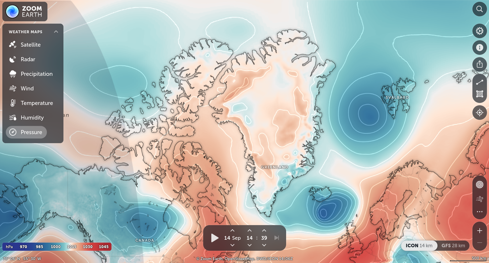
Looking at https://zoom.earth/maps/pressure/

Given the much lower temperatures at the poles, I would expect the pressure to be (much) higher.

I'm reading here and there that air pressure at the antarctic is low because of its high altitude, but these maps show (I presume?) MSLP?

5
6


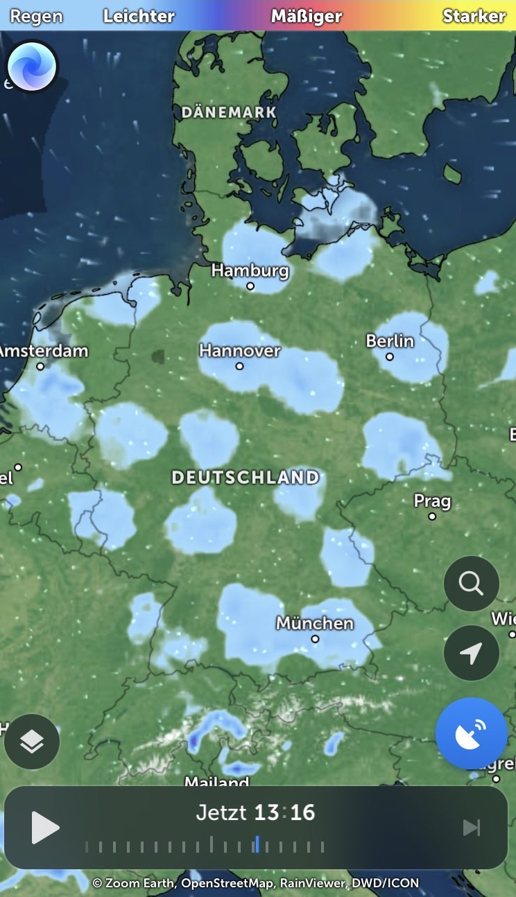
A bug in the matrix or just the radar? This is no normal cloud-shape, is it?

7


The Met Office has briefed the Government and transport chiefs to prepare for at least 50 days of rain in the next three months, leading to fears over further flooding in the UK and dashing any hopes of a warm British summer.

Last summer saw 40 days of rain, but the Met Office expects this summer to be even worse, jeopardising popular summer events such as Wimbledon, Trooping of the Colour, Royal Ascot and many festivals including Glastonbury.

...

The UK’s wettest ever summer in 1912 saw rainfall on more than 55 days.

8
9


My TL;DR:

  • Yellow weather warning for rain on Friday between 2am and 9am. Covers the central, Tayside & Fife, south-west Scotland, Lothian Borders and Strathclyde areas.
  • Yellow weather warning for snow on Friday from the early hours until 9am covering central, Tayside & Fife, Grampian, Highlands & Eilean Siar and Strathclyde.
  • Yellow weather warning for wind in western areas, including parts of Scotland and Wales, and the north-west and south-west of England from 8am to 10pm on Saturday.
  • The Environment Agency had 12 flood warnings and 93 flood alerts in place in England on Thursday morning, largely in southern areas.
10
 
 
11
12
13
14
15
16


The Met Office meteorologist Jonathan Vautrey said 29C was “certainly possible and we may also climb towards 30C” by midweek in the first week of meteorological autumn as many schools open after the summer break.

The summery conditions can be tracked to a jet stream, which has been delivering largely unsettled spells of weather to the UK. It is continuing to shift north, allowing higher pressure to build widely across the UK during the weekend and into next week, according to the Met Office.

There is also the influence of the former tropical cyclone Franklin, which is still moving into the north Atlantic and amplifying the buildup of high pressure.

17
18
19
 
 
20


A technical glitch which meant BBC Weather app and website users were told to brace for chilly winter weather has now been fixed.

A problem at a third party supplier resulted in BBC platforms forecasting 7C temperatures for next week.

The data issue also meant TV weather forecasts displayed incorrect information on Thursday night

21


This has been the hottest June in the UK since 1846, (and also since 1676, using the Central England Temperature series)!

I think even with today's cooler temperatures, it'll still have beaten the records.

Schafernaker says a bit about it here: https://www.bbc.co.uk/weather/features/66055520

22


Me, I'm still preparing for the next heatwave.
Underpants safely stowed in the freezer.

Going by the current long range forecasts, it's likely to stay mild and changeable until mid July.

23


For once, the hot weather is at the weekend when we don't need to do things! Decent chance of rain, which is very positive. A bit muggy all round, time to break out the dehumidifiers.

24


Too many days of 30’C spins my brain.

Sunny spells and showers today and Thursday, likely to continue on Friday. The weekend looks to be getting warm again. Possibly a good idea to get little jobs around the garden done before then!

The long outlook is looking more unsettled, unfortunately it’s a bit tricky to predict what will go on in July. Fingers crossed it’s not too hot…