1

A community to post about photography:
We allow a wide range of topics here including; your own images, technical questions, gear talk, photography blogs etc. Please be respectful and don't spam.
A multi-use path developed for bikes, this hike may be shortened to I believe as low as 4.4 miles while still seeing the amazing hoodoos they have to offer. I also saw a Dusky Grouse strutting about. Hoodoos are fin-like rays and ridiculous for the ease of access. Near Radium Hot Springs/Kootenay National Park.

The two tower like collections of finned hoodoos at the end of the two outcrops.

The upper tower area of one hoodoo set above Toby Creek.

This ridge line of hoodoos has thinned to little more than a single row. Toby Creek with glacial melt in it flows below.

Here are some photos of the Dusky Grouse I saw while hiking on The Johnson, which I also posted today. Pretty sparse forest so I got to watch it strut its way in and out of cover, never taking its eye off of me.

Keeping its eye on me as it gets into a thicket.

A nice angle showing rear tail and the front side as the Dusky Grouse picked its way through the woods.

One last glance over it's shoulder, the Dusky Grouse soon disappeared from sight.

A lady walks home alone at night. I hope she’ll be okay.
Thanks for seeing my work!

Hard 7.5 mi lollipop, could be shortened to a Moderate 6 mi ~2,000 ft elevation gain (~1200 mod) Hiked 6/14/25
One of my favorite hikes in Canada, this epic hike takes you along the bowl beneath Stanley Glacier. It begins with a moderate ascent in forest and then flattens as it enters the bowl. From here the trail is officially unmaintained, high use marks the trails. Absolutely recommend doing full hike.

A section of Stanley glacier that is visible from below. I believe this photo was continuing on to the summit trail, which I briefly hiked up.

A cascading stream flows out from the spillway of Stanley Glacier.

A photo showcasing the entirety of the seasonal fall cascading down.

Parts of the Shadow Mountain range in are lit up as the sun breaks free finally.

Various crags along Shadow mountain jut up toward the sky.

Looking into the large bowl from approximately where the trail switches to 'unmaintained', although it is still so well trafficked that it is well defined. Trail becomes a loop from this point.

Looking down the valley from the upper bowl area. The fall may be seen on the left with Mount Whymper outside of the valley center.
From smarholmen outside Gothenburg — at around midnight

Easy 1.2 mi Out and Back 394 ft Elevation Gain Hiked 6/13/25
Generally easy with a small washout section during the ascent part of this quick hike, a double waterfall awaits at the end of the trail. One vantage point of the falls with some lower access, I don't believe you can get to the base of it. Great as an 'after hike' or if you just want a small hike.

The water lazily flows downstream from the unseen falls in this last flat area before the quick ascent to the main falls.

The steep quarter mile or so passes over a small washout section, but not bad.

[https://bsky.app/profile/everydayhiker.bsky.social/post/3ltzxw3xkac2y](Bluesky Post) with short video of falls

Photographer @balsoft@lemmy.ml
Sunrise in Wadi Rum desert. Taken from my phone with OpenCamera's stacked HDR.

This one is from today, was pretty stoked to see it, after being pretty spooked to see it. Seen on the Petrified Forest Loop trail at Teddy Roosevelt NP. Was watching a bird that had taken iff and the next thing I knew it was giving me the heads up.

Another shot of the Prairie Rattlesnake still raised up but calming down.

Got a little to the side of the Rattlesnake as it calmed even more but remained partially raised up.

Another shot of the Prarie Rattlesnake moving along the trail. shortly thereafter it went to setup just off the trail and I moved along well off trail on the other side.
Couple videos on the Bluesky post of it slithering away along the trail.

9.5 mi loop with spurs ~2,800 ft elevation gain Hiked 6/12/25
The route that I took, going clockwise. Definitely the way to do this hike if you are up to it. Almost 3k elev. but the only tome the trail degrades is between Agnes and big beehive, which is up a washout/avalanche zone. Snowpile at bottom was a little iffy. Clouds along the ridge gave a spooky vibe.
Looking down the steep slope between Lake Agnes and Big Beehive. Trail may be seen switchbacking multiple times on the way down.

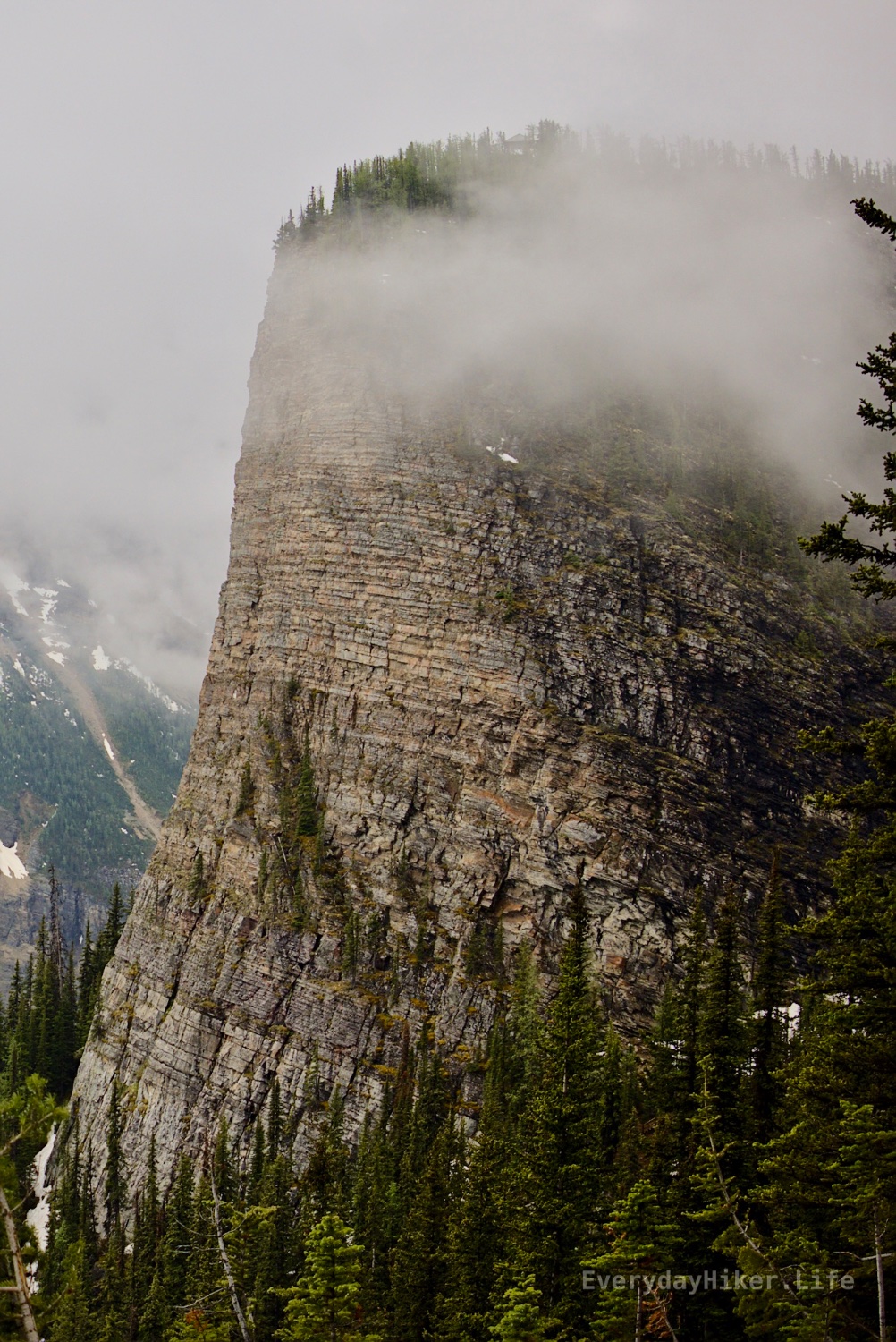
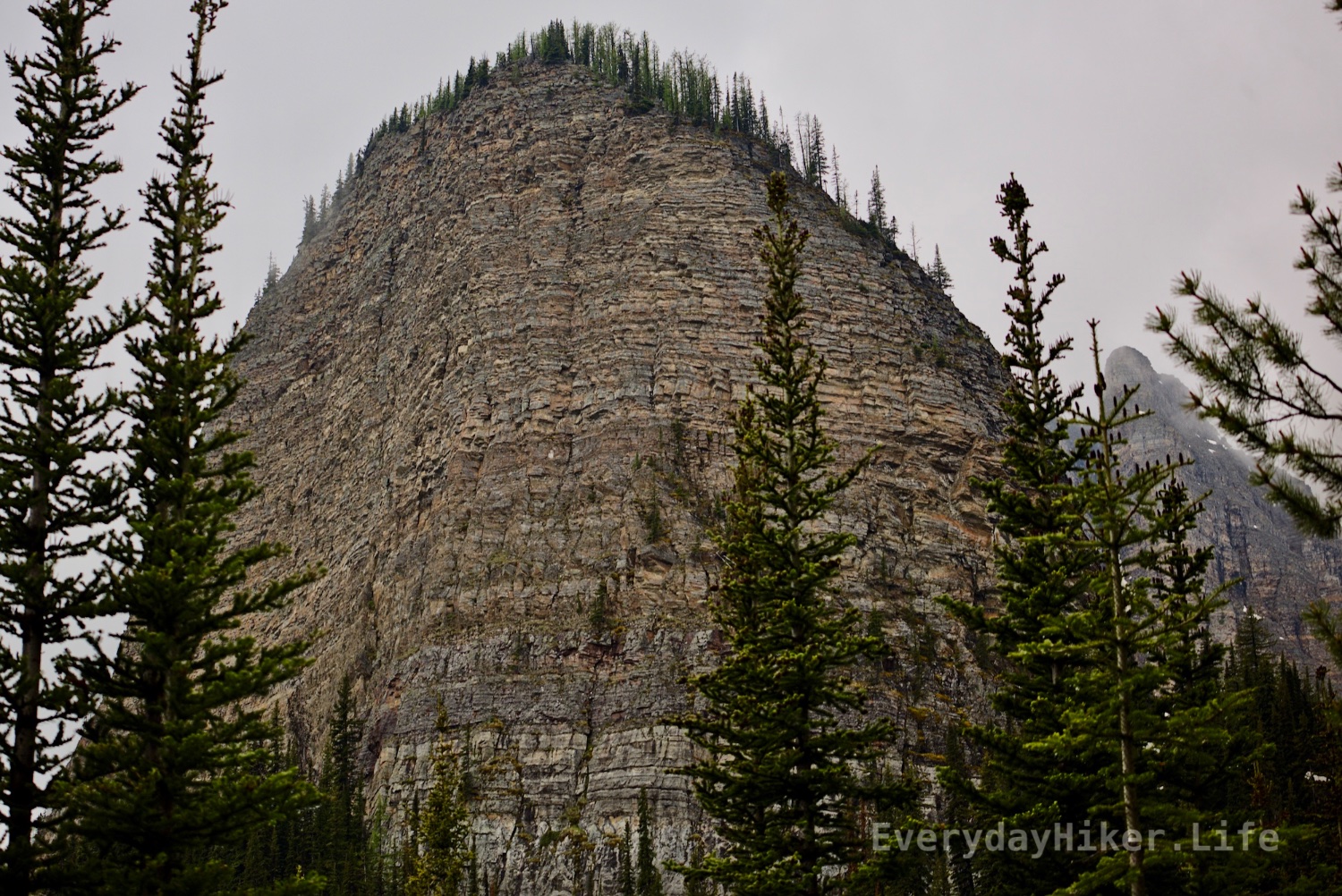
The trail between Lake Agnes and the Big Beehive runs along an avalanche route and had only recently begun being hikeable for the season. This upper area had a lot of washout and minor snow to frustrate your crossing. Part of Devil’s thumb rises above on the right in the mist.

The steep switchback section between Lake Agnes and Big Beehive above can be seen on the opposite shore. Crossed a couple of piles of snow at top and bottom with the lower being the worst to cross.
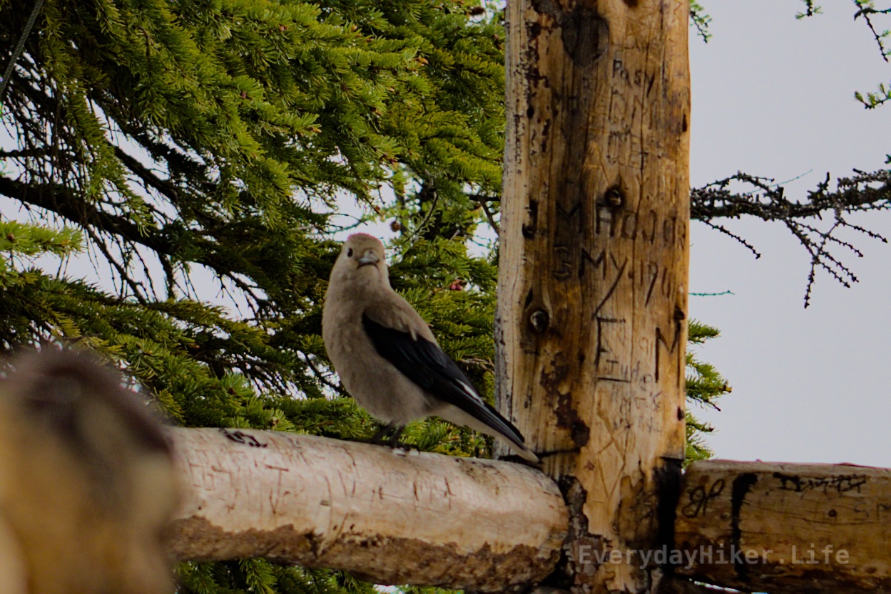
A Eurasian-Collared Dove pretending I didn't catch it carving it's name on the lookout. 'Who-Whoo-Who?"

A friend of mine had let me up to her 16th floor balcony, and she had a fantastic view of the city.
Thanks for seeing my work!

Moderate 7.3 mi out and back 2,270 ft elevation gain Hiked 6/12/25
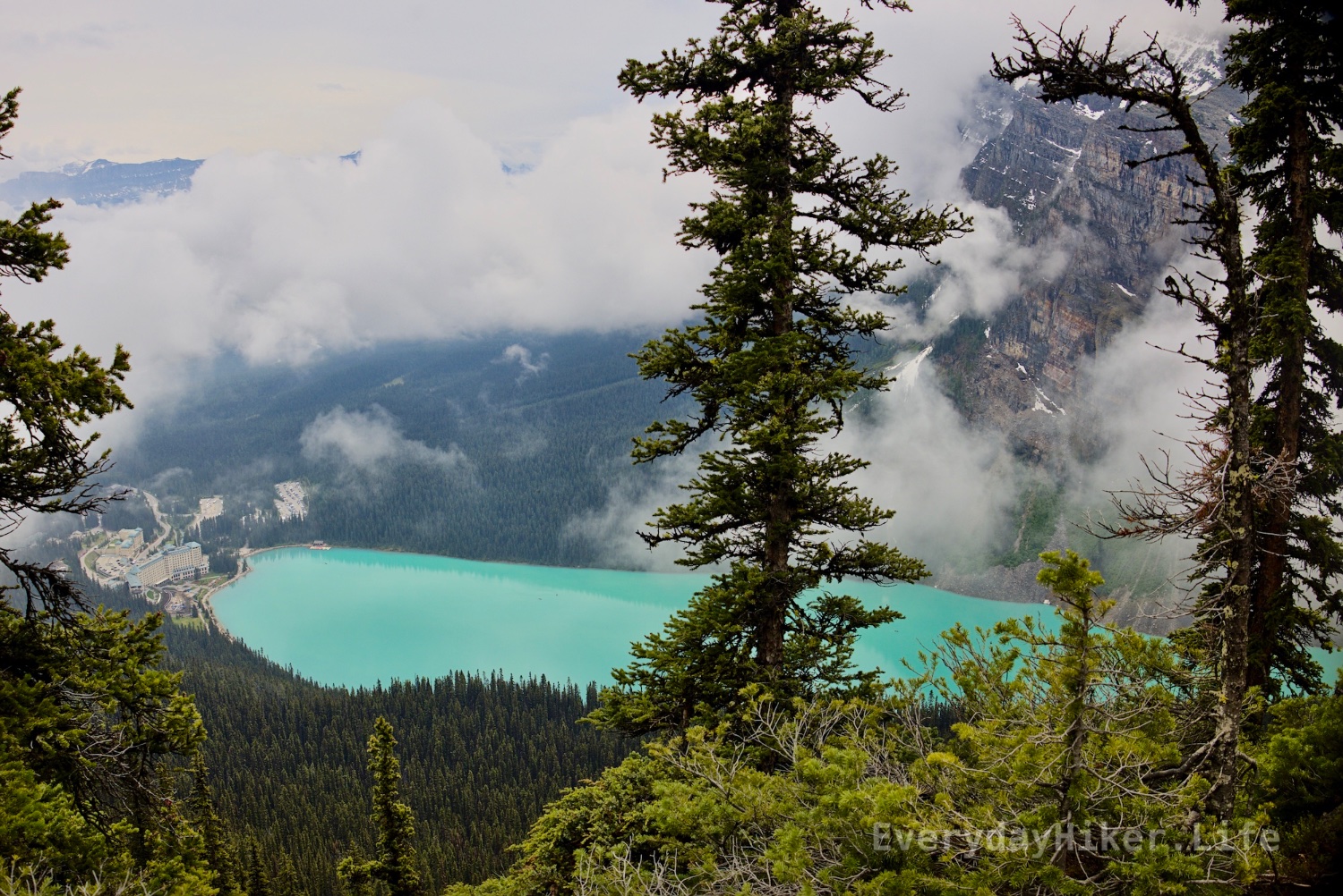
Little Beehive is the easier to ascend of the two and maintains a similar trail to previous sections, although a little steeper at times. Provides nice overhead views of (clouds) the turquoise Lake Louise and Mirror Lake as well as a side view of Big Beehive. Skips rear of Lake Agnes and Big Beehive, instead going down the side of it to make a loop.

Lake Louise and Hotel along with Mirror lake (smaller, right) sit among the trees in this rare gap in the clouds on my hike.
A side shot of the vertical face of Big Beehive, the lookout tower is barely peeking out in the stretch of cloud along the top.

The view from Little Beehive Watchtower is just as clouded as from the Big Beehive.
Moderate 4.2-5 mi out and back ~1450 ft elevation gain
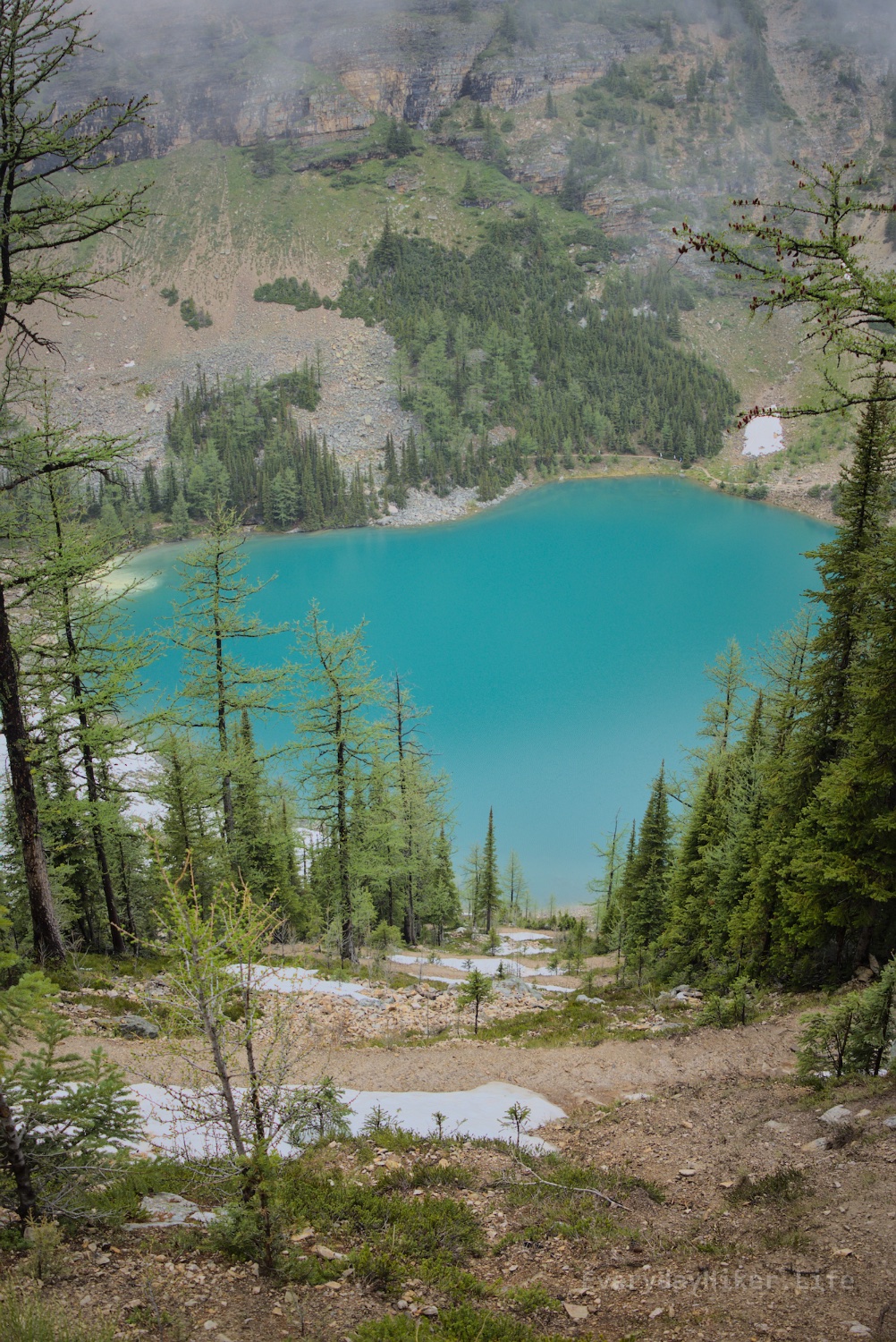
No trip to Lake Louise would be complete without a hike up to the Lake Agnes teahouse, which passes by Mirror lake along the way as well as an up close view of the waterfall leaving Agnes. Adding less than a mile to this section will go to the back side of the lake, with views of the Devils thumb.

A side shot of the upper section of the waterfall that flows out from Agnes Lake.

Swirls of pollen seen floating on this side of the Blue-Green Lake Agnes. The teahouse is on the distant shore and what may be seen of Big Beehive sits to the right.

Looking from the teahouse area of Lake Agnes towards the Devil's Thumb, mirrored in the shallow water.
Looking up towards Big Beehive as the clouds briefly parted around it for the most complete shot of it I got. The Devil’s Thumb can be seen in the distance center right.

This fine lady was just standing there. Close enough for me to get about fifty frames off, and well-lit enough for me to do it with a handheld telephoto lens.
I hope I did her justice.
Thanks for seeing my work!

Nature walk, 0-2.8 mi out and back 324 ft elevation gain
What could probably be described as the flagship hike of the flagship national park in Canada, the base version of this trail is a short walk alongside the fabulous Lake Louise. The hardest part of this section is dealing with parking or shuttle. Connects to Lake Agnes and big/little Beehives.
When I did all this, I went to the far end of Lake Louise, then up to Big Beehive along what may still be the plains of six glaciers trail, then down to Lake Agnes, up to Little beehive and then down the main way to the beginning. I found this route enjoyable as it went against the crowds instead of fighting through them. I will be posting in a different order though, which I think is the ‘normal route.’

Mount Aberdeen rises out of the clouds on this misty morning.

Fairview mountain (left) and Sheol Mountain (right) Peaking up out of the clouds, with a spiky ridge/peak between them.

Looking across the turquoise waters of Lake Louise towards Fairview Mountain.

Easy 6.7 mi out and back Elevation gain 866 ft *Alltrails misrepresents this as 2k ft both as a trail and when tracking in the app. My garmin reading of 866 ft feels far more accurate to what it was (as usual). Hiked 6/13/25
A steady but forgiving uphill hike towards Boom lake stays mostly tucked into the forest, with occasional views beyond for most of the hike. Trail drops back down to reach the lake with Boom mountain on the opposite shore. A large boulder field runs from Mt Bell to where the trail meets the lake. Rainy and overcast on the day I hiked, but the lake was a deep green color.

Looking south across Boom Lake, towards the ridgeline of Boom Mountain and an avalanche zone at its feet.

Chickaboom (left) and Chickadee Peak as seen from the boulder field at Boom Lake.

A boardwalk section takes you through the marshy part of the watershed near the lake.

The yellow moon rolling over Mont Blanc with lac leman in the foreground. Wish i had a better camera.

Moderate 7 mi out and back 1,850 ft elevation Hiked 6/11/25
Adding ~1k ft and doubling the distance of Johnston Canyon trail will take you to the InkPots, low flow cold springs. 5 pools each have different flow rates seeping into sandy bottoms, some bubble while others barely make waves in sand and leave designs behind. Views from valley of surrounding mountains.


Mystic peak shrouded in smoke makes it appear far more distant than it is.

Block mountain (left) and some of Noetic (center) and Mystic peak to the right surround this valley. I believe the smoke was from the Saskatchewan wildfires going on at the time.

3.5 mi out and back 900 ft gain
Another very popular trail in Banff that takes you up Johnston canyon, where you will pass several waterfalls along the way and walk along boardwalks raised above the river below. One falls has a cave (and a line) with a view. Extends up to the Inkpots (mod.) and beyond. Begins across from camp, although adding moose meadows (9 mi w/inkpots) would allow you to start at the less crowded lot. The moose meadow section doesn’t really add much so I’ll be ignoring it in today and tomorrow’s trails.
(Only had my zoom lens that day, which is why I don’t have a complete main falls shot)

A nice two tiered waterfall that you pass along the trail.

A couple of the bands for the largest waterfall on the trail. There were 5 or 6 total bands of this size, with a couple of them semi-merged. Forgot the wide angle lens, but this is roughly half the height as well.

One of the two main waterfalls along Johnston creek, an unseen cave on the right provides a closer viewing window, but may have a line to wait in. When I was there, this line was way too deep for me to wait around on, but better planning and it may be cool.

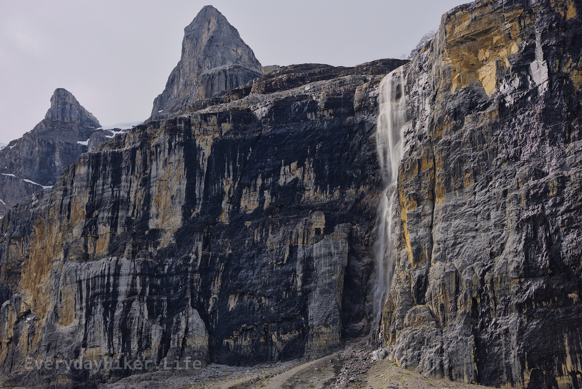
Hard, 17.2 mi out and back 4,656 ft elevation gain Hiked 6/9/25
Continuing on past Healy Pass will take you through sensitive grizzly habitat (stay on trail in place) down to Egypt Lake and surrounding Egypt themed mountains. This adds 6 mi to roundtrip, and almost doubles the elev. Campground near lake is highly sought after, and would be a great base camp. Also has a through hike associated with it, but I forget where the trail goes after Egypt Lake (my turnaround).

Scarab Ridge with various patches of snow dotting the mountain and larger areas of snow in the avalanche zones. Egypt lake may be seen in the lower right and partially frozen Scarab lake center.

Glacier lilies bloom all around Egypt lake campground with Greater Pharaoh rising above.

Looking across the snow patch on top of Healy Pass towards Greater Pharaoh Peak and all of the surrounding mountains.

A wonderful hike that spends half of it’s time rising among expansive meadows, seasonally filled with glacier lilies. It begins at the Sunshine village ski resort and maintains a steady uphill throughout the majority of the hike, increasing as you reach the pass. Access to multiple different trails along route.

Looking back into the meadow from near the top of Healy Pass. Glacier lilies dot the lamdscape while The Monarch (right) and the various mountains nearby Mt Jimmie Simpson hang on to the last of their snow.

A thin snowpatch remains at the top of Healy pass as you look towards the Monarch with an unnamed seasonal pond in the bowl below.

Looking back from the top of Healy Pass towards Mt Jimmy Simpson. Various small ponds may be seen in the valley with the trees below. Smoke from the east made it a little hazy.

My first time capturing fireworks. I made some mistakes, and I think the biggest mistake I made was being married to 100 ISO, and bringing a tripod. Fortunately for me, I was sitting right at the position directly in front of the barge, so I was able to get good shots of lovely centered fireworks. In order to get my ideas right, I shot a bit underexposed, about -1.5EV, but I think it worked out, made it harder to edit though.
My opinions and beliefs about the state of the country and my status with in it as a minority aside, I saw an opportunity for photography practice, and growth in the field, and I took it.
Thank you for seeing my work!

Currently closed due to a tragic slide on 6/19/25
Moderate 6.1 mi out and back 1,027 ft elevation gain Hiked 6/7/25
An incredible fairly short hike takes you away from the magnificent Bow Lake to the huge bowl beneath Bow Glacier. One steep climb between the two areas and then you will slowly ascend within the watershed towards the falls where the trail ends. Sweeping views back down the valley towards Bow lake.

Looking south across the vibrant Bow Lake, Crowfoot mountain is the large one on the right.

Bow Glacier falls with large patches of snow along the rock face under mostly blue skies.

The mouth of the creek flowing into the stunning Bow Lake. These affluvial dumps are great because there is such a distinct division between shallow and deep. Crowfoot mountain to the right.

A seasonal waterfall found along the trail with a very cool looking pocket cave formed beside it.

